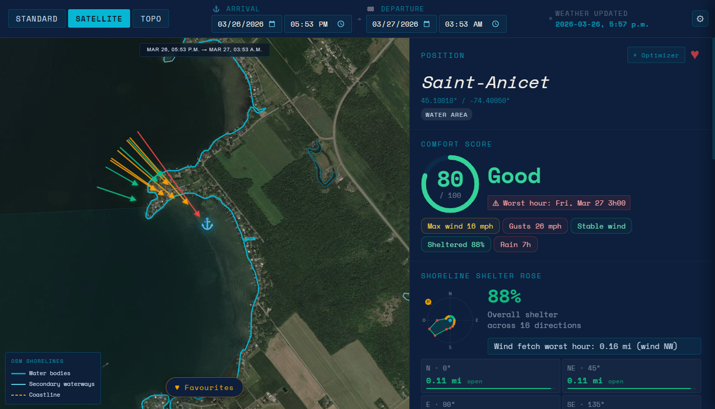
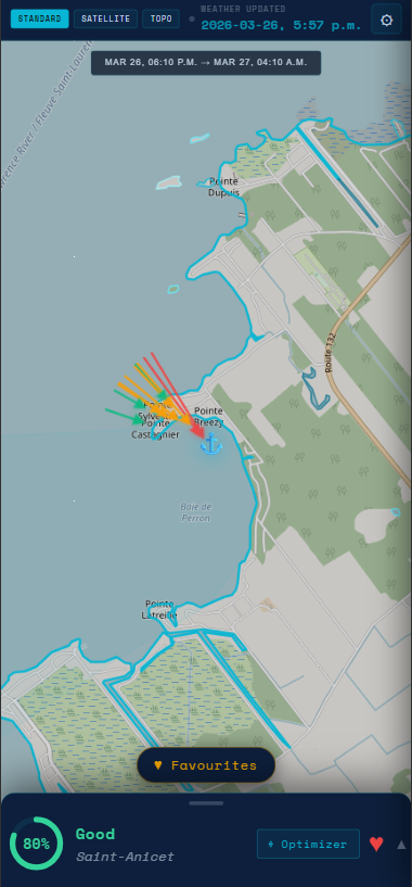
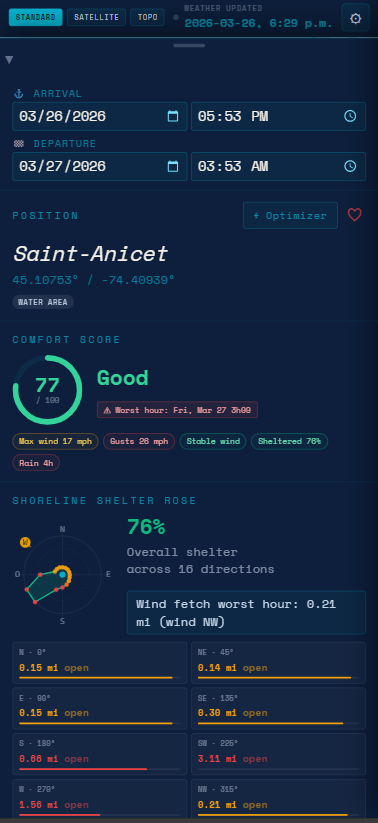
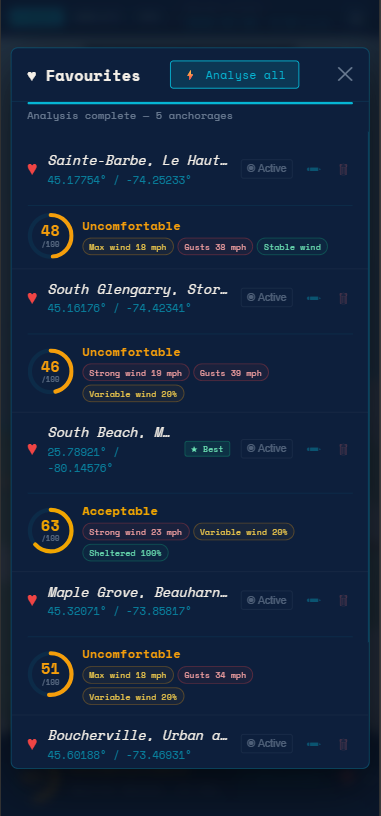
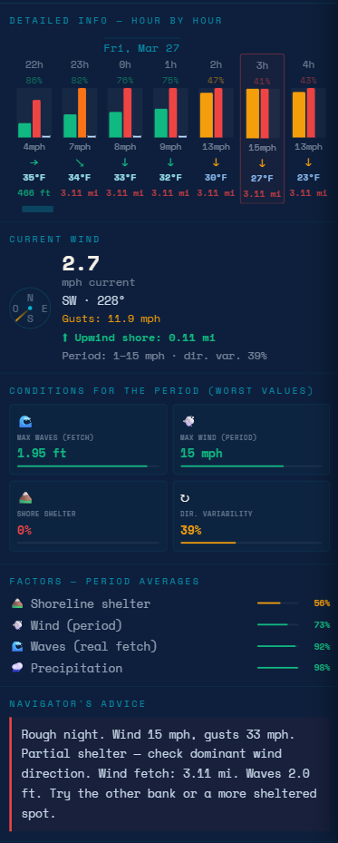
Real-time anchorage analysis that combines wind intelligence, fetch calculation, and shelter scoring — all on an interactive map. Anchor with confidence, stay confortable.
No expertise required. AnchorComfort guides you through every step so you can focus on sailing.
Select your arrival and departure date and time window for analysis.
Click anywhere on the map where you'd like to anchor — ocean, lake, or river.
AnchorComfort fetches live weather and analyzes the shoreline profile automatically.
Get your comfort score (0–100) with full breakdowns of wind, fetch, and shelter.
Add favorites, rename them, and batch-compare multiple anchorages at once.
Sophisticated analysis tools wrapped in a simple, intuitive interface designed for sailors at every level.
Click anywhere on the water — ocean, lake, or river. Works with Standard, Satellite, and Topo map views including nautical charts via OpenSeaMap.
Your single most important number. A visual score ring instantly tells you how comfortable and protected an anchorage will be — with a plain-language explanation.
Live wind speed, gusts, direction, and a visual compass. Know exactly what the wind is doing and where it's coming from, right now and in the hours ahead.
Advanced directional exposure calculation shows exactly which sectors are exposed and which are protected. Fetch calculates wave-building distance automatically.
Scroll through an hour-by-hour timeline to identify the best anchoring windows, worst conditions, and plan overnight stays with confidence.
Save up to 20 anchor spots, rename them, and re-analyze anytime. Batch-compare multiple favorites automatically to find the best option.
Not happy with your score? The position optimizer suggests a nearby location with better protection and a higher comfort score — instantly.
Context-aware recommendations flag safe conditions, issue warnings, and highlight danger periods so you always know what to watch for.
Available in English, French, and Spanish so every sailor gets information in their own language. More languages coming soon.
Every view in AnchorComfort is crafted to give you the right information at the right time.
Navigate an interactive map with real nautical overlays (If available in OpenSeaMap). Tap any point in the water to instantly begin analysis — the map is your command center.
The comfort score is your single most important data point. Combining wind, fetch, gusts, and shelter into a 0–100 rating with a clear visual ring and navigator's advice.
Save your best spots, rename them for easy recall, and let AnchorComfort automatically re-analyze and rank them so you always choose the best option.
Dive deep into the full forecast window. Scroll through every hour, inspect the worst conditions expected across any period, and read a plain-language Navigator's Advice — so you know exactly what the night holds before you set the anchor.
The sea doesn't forgive poor decisions. AnchorComfort turns complex environmental data into clear, actionable guidance.
Know before you drop the anchor. AnchorComfort flags exposed, high-fetch locations that could put you and your vessel at risk — especially overnight.
Choose spots with confidence. A high comfort score means calm water, good shelter, and a restful night — not worrying about dragging your anchor at 3am.
Fetch is the silent threat most sailors overlook. AnchorComfort automatically calculates how much wave energy is building on the water and shows it clearly.
No need to cross-reference charts, weather apps, and your own calculations. Everything you need is in one screen, ready in seconds.
AnchorComfort is a Progressive Web App (PWA). Install it directly from your browser on any device. Up to 3 devices per subscription.
Navigate to navitechautomation.ca/anchorcomfort in Safari or Chrome on your iPhone or iPad.
In Safari, tap the Share icon (box with an upward arrow) at the bottom of the screen. In Chrome, tap the three-dot menu at the top right.
Scroll through the share sheet and tap "Add to Home Screen". Confirm by tapping "Add" in the top right corner.
Tap the AnchorComfort icon on your home screen. The app opens full-screen, just like a native iOS app.
Navigate to navitechautomation.ca/anchorcomfort using Google Chrome on your Android phone or tablet.
Tap the three vertical dots (⋮) in the top-right corner of Chrome to open the browser menu.
Tap "Add to Home screen" or "Install app" from the menu. Confirm installation when prompted.
Find AnchorComfort in your app drawer or home screen. It launches as a standalone app with full-screen experience.
Visit navitechautomation.ca/anchorcomfort in Google Chrome on Windows, macOS, or Linux.
In Chrome's address bar, you'll see a computer screen icon (⊕) or a download icon on the right side indicating the app can be installed.
Click the install icon and then "Install" in the dialog. AnchorComfort will be added to your applications and taskbar.
Open AnchorComfort from your desktop shortcut or app launcher. It runs in its own window without browser chrome — just like a native app. Note: desktop counts as one of your 3 devices.
One subscription, all features. No hidden fees. Secure payments powered by Stripe.
Your subscription remains active until the end of the billing period, even if cancelled early.
AnchorComfort is built with your privacy and security at the core — both on the water and online.
All transactions are handled by Stripe, a globally trusted payment platform used by millions. Your payment details are never stored on our servers — ever.
We only collect the data necessary to provide the service. Your location data is used for analysis only, processed locally, and never sold or shared with third parties.
AnchorComfort uses trusted open-source weather and map data — Open-Meteo, OpenStreetMap, Overpass API, Nominatim, and OpenSeaMap — so you always get accurate results.
Everything you need to know about AnchorComfort, how it works, and how to get started.
AnchorComfort is a smart anchorage analysis tool that helps sailors and boaters find the safest and most comfortable place to anchor based on real-time weather, wind, and environmental conditions. It gives you a comfort score (0–100), along with wind analysis, fetch calculations, shelter mapping, and navigator's advice — all on an interactive map.
AnchorComfort is designed for sailors, boaters, and cruisers of all experience levels who anchor in lakes, rivers, or coastal waters. Whether you're new to anchoring or an experienced offshore sailor, the app simplifies decision-making and helps you avoid risky situations.
The comfort score (0–100) combines multiple factors: wind speed and gusts, wind direction, fetch (the distance wind travels over open water creating waves), and shelter/exposure analysis. A higher score means a more comfortable, protected anchorage. The score is accompanied by a visual ring, a clear label (Comfortable / Warning / Dangerous), and detailed factor breakdowns.
Fetch is the distance wind travels over open water. The longer the fetch, the bigger the waves — even if wind speed seems moderate. A spot with 10 knots of wind but 20km of fetch can be rougher than a spot with 15 knots and only 1km of fetch. AnchorComfort automatically calculates directional fetch for you, which is what makes it uniquely powerful.
Yes. AnchorComfort includes an hour-by-hour timeline view of upcoming conditions so you can identify the best anchoring windows, anticipate worsening weather, and plan overnight stays with confidence. Simply set your arrival and departure date range before tapping your anchorage location.
Yes. AnchorComfort is a Progressive Web App (PWA), which means you install it directly from your browser — no App Store or Google Play required. It works on iPhone and iPad (Safari or Chrome), Android (Chrome), and desktop (Chrome). Each subscription allows up to 3 device installations.
AnchorComfort works on any modern device with a compatible browser: iPhone and iPad (iOS, via Safari or Chrome), Android phones and tablets (Chrome), and desktop computers running Windows, macOS, or Linux (Chrome). You can have up to 3 devices installed per subscription.
No. AnchorComfort requires an internet connection because weather data, wind forecasts, and geolocation analysis all depend on live data sources. We recommend checking conditions before heading out to a low-signal area and saving your results for reference.
AnchorComfort is offered as an annual subscription. Once you subscribe, you get immediate access to all features. You can cancel anytime — your subscription remains active until the end of the current billing period, and you won't be charged again after cancellation.
Absolutely. All payments are processed securely by Stripe, one of the world's most trusted payment platforms. Your credit card or payment details are never stored on Navitech Automation's servers — Stripe handles everything with bank-level encryption and compliance.
No. AnchorComfort is designed to complement your existing navigation tools and good seamanship — not replace them. It's a decision-support tool that provides highly relevant insight. Always use your own judgment, local knowledge, and standard safety equipment when anchoring.
To save mobile data, the shoreline profile is loaded only within a 20 km radius. Because of this limited data, the app cannot determine whether an anchor position is in water or on land — checking this everywhere would require too much data.
Have a question, found a bug, or have a great idea to share? We'd love to hear from you. Our team is here to help.
✉️ info@navitechautomation.ca